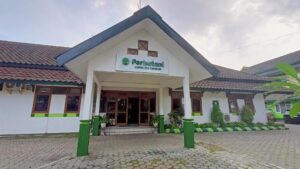
Perum Perhutani Forest Management Unit (KPH) Pasuruan is one of the management units within the Perum Perhutani Regional Division of East Java.
The working area of KPH Pasuruan, based on Government Regulation No. 72 of 2010 concerning the State Forestry Public Corporation (Perum), covers 31,871.37 hectares and is located within the administrative regions of Pasuruan Regency (21,115.57 ha), Mojokerto Regency (10,026.80 ha), and Malang Regency (729.00 ha) in East Java Province, with the following territorial boundaries:
- North side : Madura Strait (Pasuruan) dan Kabupaten Sidoarjo (Kec Porong)
- East side : KPH Probolinggo (Mountain Penanjakan)
- South side : KPH Malang (Kec.Lawang, Sumber Porong Village)
- West side : KPH Mojokerto (Kec.Mojosari) & KPH Jombang ( Kec.Jatirejo, Desa Jabng)
Based on land suitability, the forest area of KPH Pasuruan is divided into two Enterprise Classes (KP): Teak (Jati) covering 8,266.21 hectares and Mixed Forest (Rimba) covering 23,605.16 hectares.
Forest Functions :
- Production Forest (HP) covering an area of 20.341,24 Ha
- Protected Forest (HL) covering an area of 11.530,13 Ha.
Based on Government Regulation No. 72 of 2010 concerning the State Forestry Public Corporation (Perum), KPH Pasuruan is divided into several Forest Sections (BH):
- BH Jatirejo covering an area of 310,71 Ha
- BH Pacet covering an area of 186,95 Ha
- BH Penanggungan covering an area of 513,50 Ha
- BH Tretes covering an area of 691.30 Ha
- BH Nongkojajar covering an area of 064,80 Ha
- BH Tosari covering an area of 148,61 Ha
- BH Pasuruan covering an area of 955,50 Ha
Based on the management area, KPH Pasuruan consists of 7 Forest Management Subunits (BKPH) and 29 Forest Management Resorts (RPH), with the following details:
- BKPH Jatirejo = 4.310,71 Ha
-
- RPH Manting = 1.678,53 Ha
- RPH Pandansari = 1.641,41 Ha
- RPH Sumberjati = 990,77 Ha
- BKPH Pasuruan = 3.955,50 Ha
-
- Karanglo = 606,48 Ha
- Kedungpengaron = 411,22 Ha
- Plososari = 795,50 Ha
- Sruwi = 773,00 Ha
- Tanjunganom = 1.369,30 Ha
- BKPH West Lawang = 3.691,30 Ha
-
- RPH Dayurejo = 1.054,53 Ha
- RPH Jatiarjo = 1.093,89 Ha
- RPH Prigen = 612,96 Ha
- RPH Wonorejo = 929,92
- BKPH East Lawang = 5.064,80 Ha
-
- RPH Cowek = 1.010,53 Ha
- RPH Gerbo = 962,70 Ha
- RPH Martopuro = 874,15 Ha
- RPH Nongkojajar = 850,03 Ha
- RPH Sugro = 1.367,39
-
- RPH Claket = 848,05 Ha
- RPH Kemiri = 690,83 Ha
- RPH Kemloko = 1.648,07 Ha
- BKPH Penanggungan = 3.513,50 Ha
-
- RPH Betro = 665,96 Ha
- RPH Ngoro = 1.306,02 Ha
- RPH Seloliman = 666,42 Ha
- RPH Trawas = 875,10 Ha
- BKPH Tosari = 8.148,61 Ha
-
- RPH Manting = 1.971,85 Ha
- RPH Pandansari = 1.597,50 Ha
- RPH Sumberjati = 1.980,41 Ha
- RPH Penanjakan = 804,50 Ha
- RPH Puspo = 1.794,35 Ha
The total number of employees at KPH Pasuruan is 187 people. (See on : KPH Map)
Public Summary
Kelola Produksi
Kelola Lingkungan
Kelola Sosial
Administratur Name : Ivan Cahyo Susanto
Alamat : Jl. Terusan Kawi No.1 Bareng, Kec. Klojen
Tlp / Fax : –
Email : kph.pasuruan@perhutani.co.id

